It’s been a full fall and early winter of working, schooling, and exploring the outdoors. Today, however, is a rainy day in January, perhaps the best type of weather to reminisce on past explorations. After some time off from this blog, I intend to share some highlights from my last adventure with you all – a trek with my exploring buddy Jen, our longest and most taxing expedition together to date.
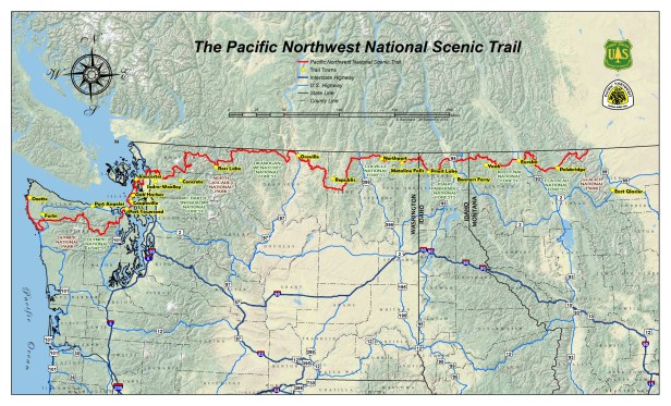
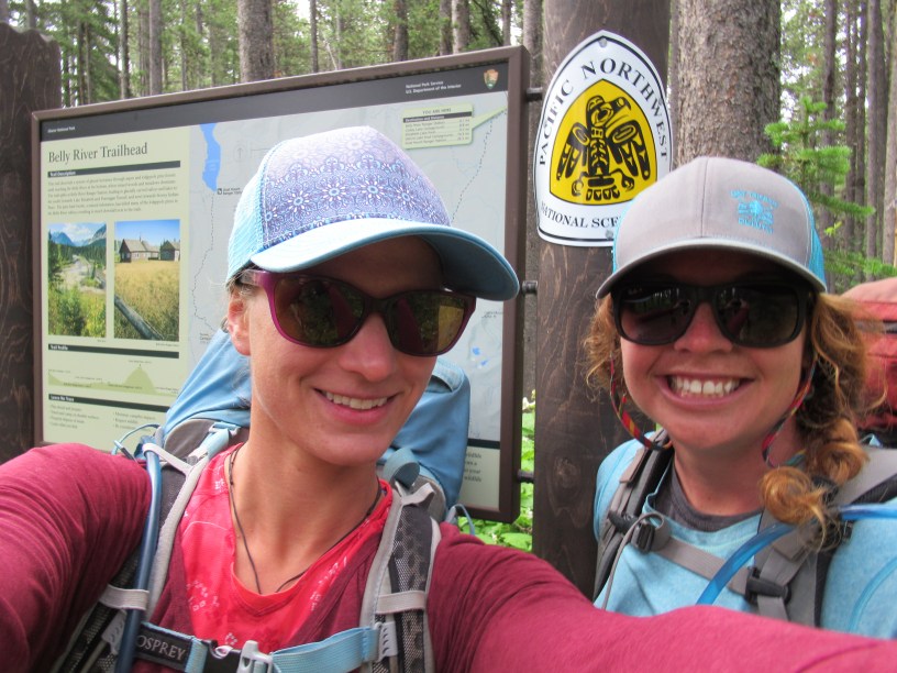
We started in Glacier National Park at Chief Mountain Customs on July 4th, and headed west along the Pacific Northwest Trail (PNT) for about five weeks (after which we had to return home to honor prior commitments). The PNT is a loosely defined footpath that links Glacier National Park in Montana with Olympic National Park in Washington. It connects a myriad of trails and non-trails: national parks trails, national forest roads and trails, state land, the occasional paved road and highway, and bushwhacking when there is no trail. Some trails are well maintained, in some areas the trail is obliterated by recent fire, in areas the trail is so overgrown that one might as well call it bushwhacking. It is mountainous along its entire route as it travels through northern Montana, Idaho, and Washington. From its start in Glacier (the Rocky Mountains), it travels over the Purcell Range, followed by the Selkirks, the Kettle River Range, and then the Okanogan Highlands – and this is only in the half of the trail that we managed to make it to! There are quite a few that we’ll cross over as we continue our adventure in the future.


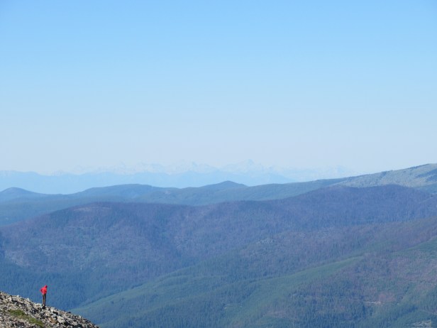
The PNT offers quite a few ‘alternate routes’ so it is very much like a masochistic Choose Your Own Adventure novel. Route finding and navigation skills are necessary – and even with them, getting off track and backtracking is part of the adventure. The official trail frequently takes sharp turns to hike to nearly the top of nearby peaks (but not necessarily to summit them) before making a u-turn and coming right back down. Water and flat land for camping is limited, so one must get creative at times to find somewhere to sleep. The mosquitoes can be next level, an added insult when, apparently, the next water source is nearly 20 miles away. Finally, heading westbound, you have at least 350 miles (if not more) where you might run into a grizzly bear. As one would guess, all of this led to some hilarious stories, which I plan to share with you soon in more detail.


Despite the challenges, our country has some fantastic mountains and the vastness of our public spaces is incredible. I think that driving across the West gives some perspective as to how big our country is, but walking really lets it sink in. A friend described his experience looking out at one of the mountain ranges we tromped through as, “It sounds like distance, it reeks like miles.” In this vastness hung the reminder that we are visitors on the land, and a healthy respect that these mountains were here long before we came to be, and will be here long after we are gone.
In addition to experiencing some beautiful spaces through our blood, sweat, and tears, a highlight of this adventure was the people that we met along the way. This trail is not as popular as the Pacific Crest Trail or the Appalachian trail, but we still had a bit of a cohort of fellow adventurers that we kept running into. As one would guess, actively choosing to do something as bizarre as walking and bushwhacking across the West self-selects for some interesting characters. Some of these folks turned into close friends, and we ended up hiking together. Others we would see in towns and enjoy hearing of their trials and tribulations along the same paths. Additionally, locals in trail towns would help us out by giving us rides and even opening their homes and yards to host us. These people were so incredible and eclectic that they deserve their own blog post – I’ll plan to get on that in the future.
As you know by now, I’m not the most consistent when it comes to writing about my adventures. I chose not to do it while we were out this summer as I wanted to truly be present with where I was at the time, and authentically engage with the people who were with me in person. However, we shared so much laughter, met so many good people, and had so much type-two fun (not necessarily fun at the time, but is fun to look back on now) that I look forward to sharing some of the highlights with you soon.
Overview map found at: https://www.pnt.org/pnta/know-before-you-go/plan-your-trip/trail-towns-resupply/
