
July 10th – A day of days! (the first of many with this title)
Jen and a I crept forward, hearts racing, shoulder-to-shoulder with our bear sprays at the ready, yelling, “Hey bear! Good morning! Thank you for sharing your forest with us! Please don’t eat us!”
We were walking along a forest road, in the cool morning air (I think it was around 6:30 am). Up ahead, over a small hill, popped a giant blond head attached to a massive furry body. The bear looked at us for a moment before dropping down out of sight, disappearing without a sound. Of course, this is the road that is was to be our route, and it was with great trepidation that we shuffled on, calling out greetings and appeals. Luckily the bear must have had better things to do than eat us; we never saw it again.
Up and up and up we climbed for a few hours. The mosquitoes were dreadful and, as the only clothing that was impermeable to them, our rain jackets were on – resulting in puff of dank air wafting up from our sweat soaked bodies. When we reached a ‘top’ we had spectacular views, but we were always going either up or down, never flat.


Jared and Katherine caught up to us during one of our stretching breaks, and shortly thereafter we got lost. Very lost. This happened for a variety of reasons. We came into an area that had been intensely burned the year before, the trail was obliterated by thick layers of ash and fallen, charred trees. This would have been ok if we had placed ourselves accurately on the map in the first place. However, both Jen and I swore that we had seen a sign a while back placing in the next valley over from where we actually were. As we saw this sign independently from one another, we were pretty confident.


The other two had a phone app that was sending us in one direction, and my gps was sending us in another, and neither matched up to what it seemed like we should be doing according to what we thought to be true from our topo map. Additionally, we were all nearly out of water, as this was our first long stretch – and, water would have been just about a mile ahead, along the trail. If we were on it.
We headed along the steep side of the mountain, confused by our conflicting gadget information. The valley was increasingly puzzling as we tried to make the hills around us fit with the map in our hands and the signs that we had seen. We spread out, looking for the remnants of the trail. We picked our way through the rubble, climbing over charred trees, our feet sinking into inches of soft ash. Frequently we’d call to one another, in our shared search.
“Anything up there?”
“Maybe! Wait, no, never mind. It’s just a fallen tree.”
“Got anything down there?”
“Nope.”
My gps said we were neither getting closer nor farther away from our destination, and the arrow would flip on occasion, sometimes telling us to go up, and other times telling us to go down. Katherine’s app wasn’t updating our location with its signature little blue dot. As our mouths grew gummy from lack of water and the ashy, apocalyptic air, we considered descending into the valley to find water.
Instead, we decided to go over the ridge of the hill we had been walking along (I don’t remember why we decided this, but it ended up being a good decision). We headed straight up the burned ridge and down through the impossibly thick brush on the other side. The combination of thick brush and downed trees made for a lot of close calls – slips and stumbles. As we headed downward, Jared said, “Is that water that I hear?” We were all thinking it but didn’t want to get our hopes up. Sure enough we came upon a lovely, wonderful little stream – whew! Water: check. One problem solved!
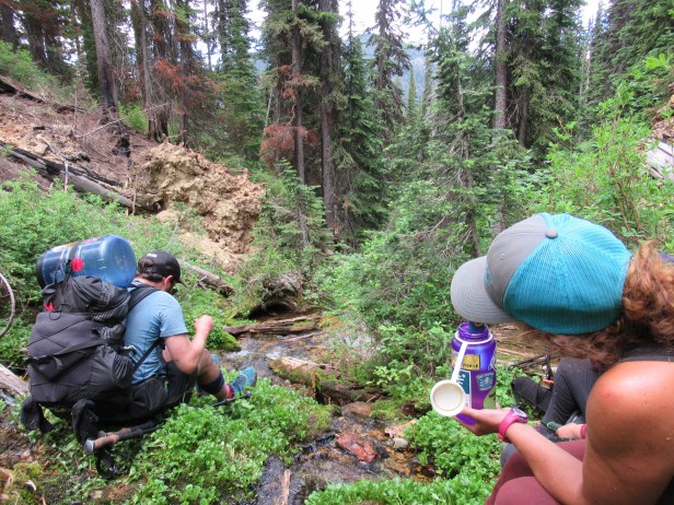
Sitting by the stream in the steep mossy crevice in the mountain, we were able to better assess our situation. One nice thing about backpacking is that you have everything with you – while our location would not make for a comfortable camping spot as it was very steep, very thick, and very wet, if we had to, we would be fine. Katherine did some monkeying around with her App and managed to triangulate where she thought we were. I recalibrated my gps and compared Katherine’s assessment of our location to the topo map. We agreed that she was probably correct (with a lot of confusion as to how we might have made it to that spot). Now the gps waypoint and the topo were matching up, so we decided to follow the stream up the mountain 0.75 mile to an intersection of two trails. Three quarters of a mile never seemed so far! The tenths of a mile slowly clicked off the gps as we fought our way up the steep slope through the thick brush. As we crested the hill into a strong gust of wind, I was never so pleased to see a trail intersection and a sign! After a multiple hour detour, we were back on track.

The whole time I couldn’t help but think of the scenario that we had made for ourselves – it was like one that we might have been given in my Wilderness First Responder training: four experienced people lose the trail in a large wilderness area and make the rash decision to keep going even though they aren’t sure where they are. They are out of water. They end up in a situation where there are lots of possibilities for sprains and strains. It is late afternoon and they are tired.
If this had been one of our WFR training scenarios, someone would have broken a bone, someone would have been diabetic, another would have had asthma, a storm would have come in, we would have ran into a hive of bees, and we would have had to spend the night on the side of the mountain. Luckily none of these things happened. Despite acquiring some scrapes and bruises, being covered in soot, and being overall exhausted, we came through generally unscathed.

This ordeal highlighted three things for me: Jared and Katherine (and Jen too of course) are wonderful humans, even experienced people make bad decisions, and sometimes you must slow down (especially on the PNT). Our little group did a stayed positive and worked together to solve our problem – there was no finger pointing or blaming, everyone was focused on finding a solution. Though we hardly knew Jared and Katherine before this mishap, we became fast friends through the shared adversity. They’ll be showing up in future stories (mostly of shared adversity) down the trail!

OMG, technology! Working together without blame, without anger was such a huge asset for you all! I bet that water felt great going down. I so enjoy hearing of your experiences!
LikeLike
Thanks pops!
LikeLike